

Guam and the Northern Mariana Islands prepare for destructive winds, flash flooding, and widespread power outages.
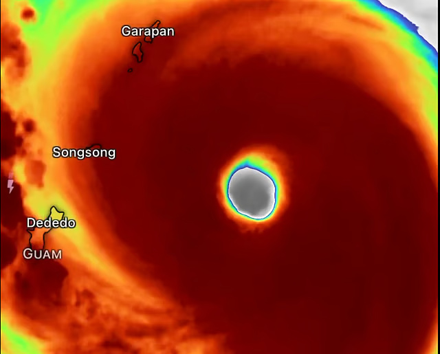
Manila: Super Typhoon Bavi has rapidly intensified into one of the strongest tropical cyclones on Earth this year, reaching Category 5 intensity with maximum sustained winds of 285 km/h (180 mph) and an estimated minimum central pressure of 901 millibars. The powerful storm is now bearing down on the Mariana Islands, raising fears of potentially catastrophic impacts.
According to the latest forecast from the Joint Typhoon Warning Center (JTWC), Bavi is expected to pass directly over or extremely close to the island of Rota within the next few hours.
The typhoon is forecast to unleash destructive winds, torrential rainfall, life-threatening storm surge, and widespread power outages across the region. Residents in Guam and the Northern Mariana Islands are also bracing for extreme weather conditions, including damaging winds, flash flooding, and prolonged disruptions to essential services.
The typhoon’s eyewall is expected to bring the most destructive conditions, with hurricane-force winds capable of causing widespread structural damage, uprooting trees, and leaving some communities uninhabitable for days or even weeks.
Meteorologists have described Bavi as one of the strongest tropical cyclones of 2026 after it underwent explosive rapid intensification over the exceptionally warm waters of the western Pacific, fueling its transformation into an extremely dangerous Category 5 storm.
Bavi strengthened by nearly 100 mph (160 km/h) in just 36 hours, fueled by exceptionally warm ocean waters and highly favorable atmospheric conditions that allowed the cyclone to rapidly intensify into a Category 5 super typhoon.
Typhoon and flash flood warnings
Typhoon and flash flood warnings remain in effect for Guam, Rota, Tinian, and Saipan, where authorities have urged residents to shelter in sturdy buildings, stay away from windows, and complete preparations before conditions deteriorate. Hurricane-force winds, dangerous flying debris, torrential rainfall, and coastal flooding are expected as the storm approaches.
Rainfall totals of 12 to 20 inches (300 to 500 mm) are forecast across parts of the Mariana Islands, significantly increasing the risk of life-threatening flash flooding and landslides.
The approaching cyclone comes less than three months after Super Typhoon Sinlaku devastated the U.S. Pacific territories, claiming 17 lives and causing an estimated $1.5 billion in damage, underscoring the region’s ongoing vulnerability to powerful tropical cyclones.
Many communities across the Northern Mariana Islands are still recovering from that disaster, with damaged infrastructure and lingering power issues persisting in some areas. The arrival of Super Typhoon Bavi has heightened concerns that the region could suffer another devastating blow before recovery efforts are complete.
Tracking toward the Philippine Sea
After passing the Mariana Islands, Super Typhoon Bavi is forecast to gradually weaken. However, forecasters warn it is expected to remain an extremely dangerous typhoon as it continues tracking west-northwest across the Philippine Sea, with its path bringing it into the vicinity of Taiwan later this week.
Meanwhile, the Philippine Atmospheric, Geophysical and Astronomical Services Administration (PAGASA) said Bavi remains outside the Philippine Area of Responsibility (PAR) and poses no direct threat to the Philippines at this time. The agency added that it is closely monitoring the powerful cyclone’s movement and any potential changes in its forecast track.