

Rain, wind, and rising humidity to impact the UAE ahead of calmer conditions expected by Friday.
Dubai: Rain returned to the UAE on Tuesday, with showers affecting several emirates throughout the afternoon as a surface low-pressure system, combined with an upper-air trough, created unstable conditions across the country. Residents in Dubai, Sharjah, Ajman, Umm Al Quwain, and parts of Abu Dhabi reported light rain during the day.
The National Centre of Meteorology (NCM) confirmed that the atmospheric disturbance would keep conditions unsettled through Tuesday evening and into Wednesday. The agency noted, however, that this system is significantly weaker than the storm that hit the country last Friday, which had caused widespread thunderstorms, lightning, and waterlogging across multiple regions.
What’s causing the rain today?
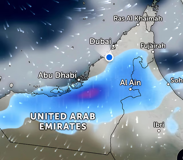
The current wet spell is driven by a surface low-pressure area interacting with an upper-level atmospheric trough. This combination is drawing moisture-laden air over the UAE, leading to cloud formation and intermittent showers across scattered areas. The NCM noted that cumulus cloud development is expected to continue into the early hours of April 1, with the heaviest rainfall concentrated over the eastern and northern regions of the country.
Winds across coastal, inland, and mountainous areas are blowing from northwest to southeast at 10–25 km/h, occasionally reaching 40 km/h. Gusts are lifting dust and sand in open terrain, causing localized reductions in visibility.
Wednesday, April 1: Rain to continue as winds strengthen
Wednesday is expected to be the more active day of the two. The NCM forecasts partly cloudy to overcast skies across much of the UAE, with recurring chances of light to moderate rainfall during the daytime. Eastern and northern areas, including parts of Fujairah, Ras Al Khaimah, and the Hajar mountain region, may experience heavier downpours at times.
Temperatures are set to dip slightly, particularly in western areas, providing a brief but noticeable relief from the recent weeks of warmth.
Northwesterly winds will pick up, with sustained speeds of 15–25 km/h and gusts reaching up to 45 km/h. These stronger gusts may lift dust and sand in exposed inland areas, reducing visibility. Motorists and residents in open zones are advised to stay alert.
Sea conditions in the Arabian Gulf are expected to worsen, becoming rough to very rough at times as the system strengthens offshore, while the Sea of Oman will see moderate to rough waves. The NCM has urged maritime operators and those planning coastal activities to exercise caution and follow updated marine advisories.
Thursday, April 2: Gradual improvement expected
Conditions are set to ease on Thursday as the low-pressure system weakens and moves away. The NCM forecasts fair to partly cloudy skies, though some eastern areas may still experience lingering low clouds in the morning.
Humidity is expected to rise Thursday night into Friday morning, potentially causing fog or mist over coastal and inland areas. Residents are advised to drive carefully in the early hours, especially on highways and elevated roads where visibility may drop sharply.
Winds will ease to light to moderate from northwest to southwest, occasionally strengthening with gusts up to 40 km/h, causing localized dust. Sea conditions in the Arabian Gulf and Sea of Oman are expected to remain moderate to rough.
Friday, April 3: Mostly fair with lingering humidity
By Friday, weather is expected to return to mostly settled conditions. The NCM forecasts fair to partly cloudy skies, with mist possible overnight and into early Saturday in some coastal and inland pockets. Winds will lighten further to 10–20 km/h, with occasional gusts up to 35 km/h. The Arabian Gulf is expected to be moderate to slight, while the Sea of Oman should calm to slight conditions.
Safety reminders during unsettled weather
The NCM and UAE authorities urge the public to take precautions during periods of active weather. Drivers should reduce speed in rainy conditions and avoid crossing wadis or low-lying roads that may flood rapidly. Residents near coastal areas should stay away from the shoreline when rough sea warnings are in effect. It is also advisable to keep emergency numbers handy and monitor official NCM updates during unsettled weather spells.
The current weather pattern is expected to be localized and relatively short-lived, with conditions gradually improving from Thursday onward.
