

Clear Skies, Light Winds and Arabian Gulf Moisture Can Trigger Sharp Drops in Visibility.
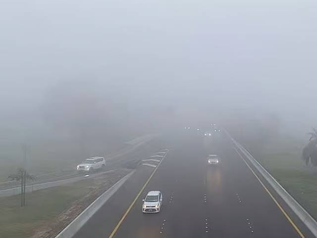
Abu Dhabi: Cooler mornings and evenings are gradually returning to the UAE, encouraging residents to spend more time outdoors, from barbecues and desert outings to other open-air activities.
However, the seasonal change also signals the return of a familiar early-morning weather hazard — dense fog that can sharply reduce visibility and, in some areas, make it difficult to see more than a short distance ahead on the roads.
As temperatures continue to ease and humidity levels increase, conditions are becoming more favourable for fog to form, particularly overnight and in the early morning hours, according to the National Centre of Meteorology (NCM).
The NCM explained that fog is most likely to develop when several weather conditions come together, including stable atmospheric conditions, light winds, clear skies and high levels of moisture close to the ground.
When these factors align, relative humidity can rise to between 90 and 100 per cent, bringing the air close to saturation and creating ideal conditions for fog formation.
Fog forms when water vapour condenses within the lowest layers of the atmosphere, creating tiny droplets of water suspended in the air.
Light or calm winds allow moisture to remain concentrated close to the surface. At the same time, falling temperatures cool the surrounding air until it approaches saturation, allowing water droplets to form and potentially causing a significant drop in horizontal visibility.
Arabian Gulf moisture moves inland
North-westerly winds can also contribute to the development of fog across the UAE.
According to the NCM, winds travelling over the Arabian Gulf during the evening and moving inland overnight can carry substantial amounts of moisture towards coastal and interior parts of the country.
When these winds weaken and atmospheric conditions become stable, moisture can build up near the ground, increasing the likelihood of fog forming and spreading across larger areas.
Several locations across the UAE have already recorded foggy conditions in recent days.
High pressure in the upper atmosphere can further support fog formation by restricting the upward movement of air from lower levels. This can trap moisture close to the surface and allow humid conditions to persist.
Cooler nights raise fog potential
The increasing likelihood of fog is also closely associated with the seasonal drop in temperatures across the UAE.
September marked the end of the UAE’s climatological summer, with temperatures beginning to gradually decline, particularly during the night and around sunrise. The cooling trend usually becomes more noticeable in the second half of the month.
Astronomical autumn began around September 23, when the sun was positioned directly over the Equator before continuing its apparent southward movement towards the Tropic of Capricorn.
Humidity levels also tend to rise compared with August, particularly towards the end of September. During the month, the average maximum relative humidity is around 77 per cent.
As the UAE progresses further into the cooler months, conditions become increasingly favourable for fog. The NCM identified December, January and February as periods when fog occurs more frequently, largely because of lower overnight temperatures.
Why radiation fog is common in the UAE
Radiation fog is among the most common types of fog experienced across the Emirates.
It develops when the ground loses heat overnight through long-wave radiation. As the surface cools, it lowers the temperature of the air immediately above it, while the air at higher levels remains relatively warmer.
This results in a surface temperature inversion, where a layer of cooler air becomes trapped beneath warmer air.
The stable atmospheric layer limits vertical air movement, allowing moisture to remain concentrated close to the surface. When temperatures fall sufficiently and the air reaches saturation, the moisture condenses into tiny water droplets, leading to the formation of fog.
Clear skies can further support the formation of radiation fog by allowing the ground to lose heat more rapidly during the night, helping temperatures near the surface fall towards the saturation point.
Strong winds can limit fog formation
High humidity by itself does not necessarily mean fog will develop.
The NCM explained that stronger winds, including active north-westerly flows, can lower the chances of fog by mixing the air close to the ground and preventing moisture from becoming concentrated near the surface.
Wind direction is another important factor, as it helps forecasters determine the origin of an air mass and whether it is bringing moist or dry conditions into the country.
How the NCM forecasts fog
The NCM uses satellite data, weather stations and atmospheric observations to monitor conditions that could lead to fog formation. One of the key indicators is the difference between air temperature and the dew point.
When the two readings move closer together, the likelihood of the air reaching saturation increases, making fog more likely to develop. A wider gap between the temperature and dew point generally indicates a lower chance of fog.
Forecasters also monitor wind speed and direction, as well as atmospheric conditions at higher levels. Upper-level high pressure can strengthen atmospheric stability, restrict the upward movement of moist air and help keep humidity trapped near the surface.
Fog and mist: What separates them?
The main difference between fog and mist is the level of horizontal visibility.
Conditions are classified as fog when horizontal visibility drops below 1,000 metres. When similar atmospheric conditions occur but visibility remains above one kilometre, they are generally classified as mist.
During particularly dense fog events, visibility can deteriorate considerably further and may approach near-zero levels in some locations, creating potentially dangerous conditions for motorists travelling during the early morning.